From the heights of Everest to a humble library, we share the most extraordinary international borders from across the globe
My name is unremarkable, most people would agree. It’s so common that if you Googled ‘Peter Watson’, you would find the intellectual historian, the author, and the arts benefactor – all different men – ahead of me. There’s also a producer, a chemist and a podcaster among others.
Sadly, we all share a name with a less illustrious Peter Watson; one wanted by Interpol I’m told. For this reason, I am never able to use the electronic gates at airports. While Kia swans through in seconds, I am often consigned to the manual queue, presumably so that the staff can check I’m not a fugitive.
This annoyance was generally manageable until I tried to cross from Poland into Belarus in 2022. Kia and I had already been stuck in a coach for four hours at the border when we were finally allowed to enter passport control where we queued for the sole open counter.
When it came to my turn, there seemed to be some confusion among the officials. None of them spoke English and, sadly, I do not speak Russian or indeed Belarusian. I began to get stressed about holding up the queue. Eventually, I was asked to step aside while the staff made some phone calls. To my relief, after 20 minutes or so, I was allowed to enter Belarus.
Crossing international borders can be laborious or effortless depending on where you are. Some borders are closely guarded; others are left alone. Most are unexceptional, but occasionally you will find one that is beautiful, illuminating or even amusing. Below, we share some of the most remarkable international borders found across the globe.
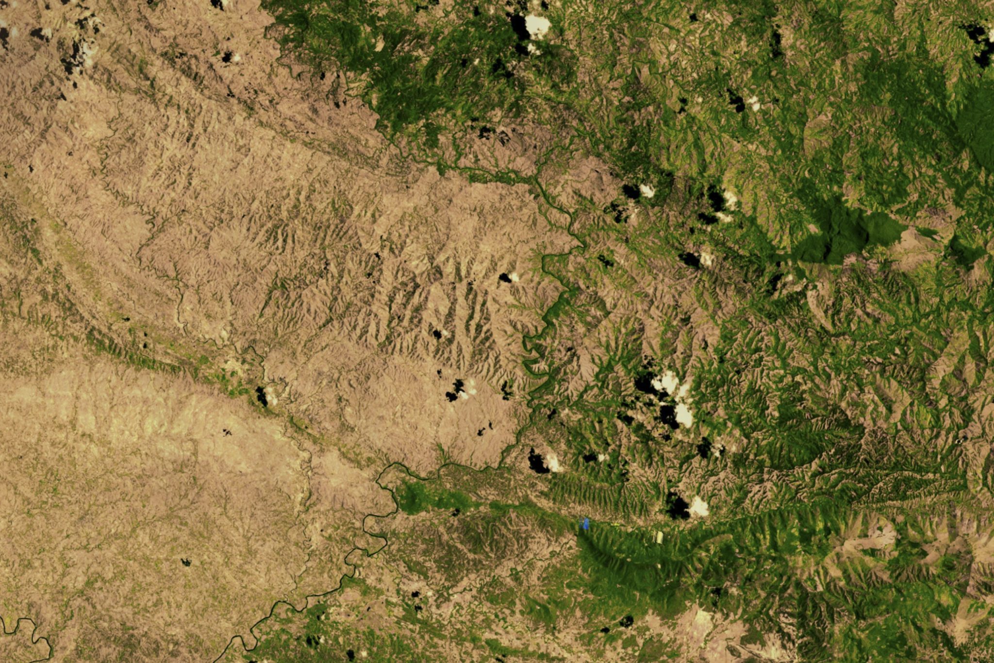
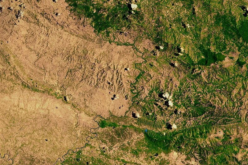
1. Nepal / China
The Nepal–China border runs all the way up Mount Everest, including the precise summit point, making it the highest international border in the world.
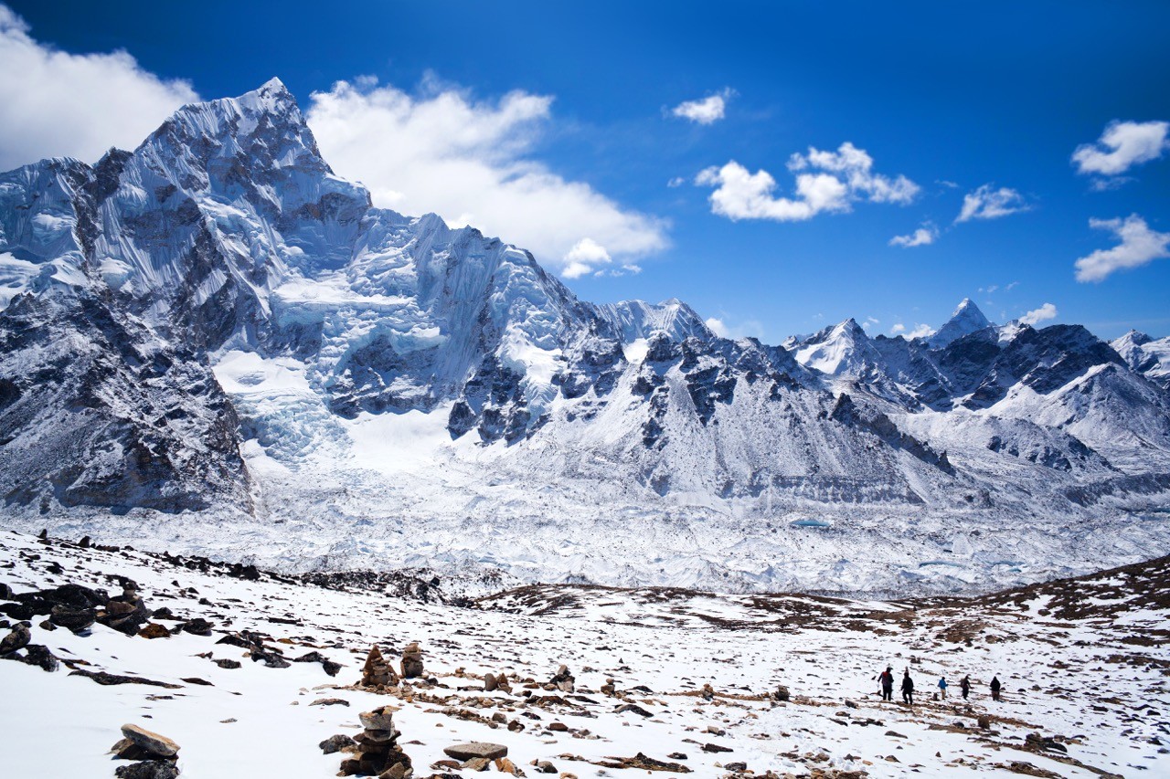
Everest can be climbed from both countries but is more frequently tackled from the Nepalese side which has better infrastructure and more experienced Sherpas to lend support to would-be summiteers.
2. Haiti / Dominican Republic
In colonial times, Haiti had a population seven times higher than its neighbour. Today, the two countries are more or less on par (11.5m in Haiti versus 11.2m in the Dominican Republic) but at half the size of its neighbour, Haiti has a far higher population density.
This in combination with low rainfall and scant legislation has led to rapid deforestation on the Haitian side.
In 2014, the country’s forest cover stood at an estimated 2%, one of the lowest rates in the world. More recent estimates, however, have put the figure at 21%. The anomaly arises because of a difference in how ‘forest’ is defined (e.g. old growth forest versus the UN definition of 10% canopy cover). Either way, corrective actions are essential if Haiti is to turn the tide on centuries of degradation.
3. USA / Canada
The Haskell Free Library and Opera House straddles Stanstead in Quebec (Canada) and Derby Line in Vermont (USA). A thin black line slices it down the middle, marking one of the quaintest international borders across the globe.

Built in 1904, the library was deliberately constructed on the border by American sawmill owner Carlos Haskell and his Canadian wife Martha Stewart Haskell to ensure availability to customers of both nationalities.
In total, there are three streets that cross the border. While security has been tightened post 9/11, residents can still cross international lines by visiting the library.
4. Alaska / Russia
During the 2008 presidential campaign, VP candidate Sarah Palin said, “I can see Russia from my house” – or so goes the legend. What the hapless Republican actually said was: “They’re our next-door neighbors, and you can actually see Russia from … an island in Alaska.”
Incidentally, she is right. The Diomede Islands, two rocky islands in the middle of the Bering Strait, lie on either side of the USA-Russia border, just 3.8 km (2.4mi) apart. Big Diomede Island is a part of Russia while Little Diomede is a part of the US state of Alaska.
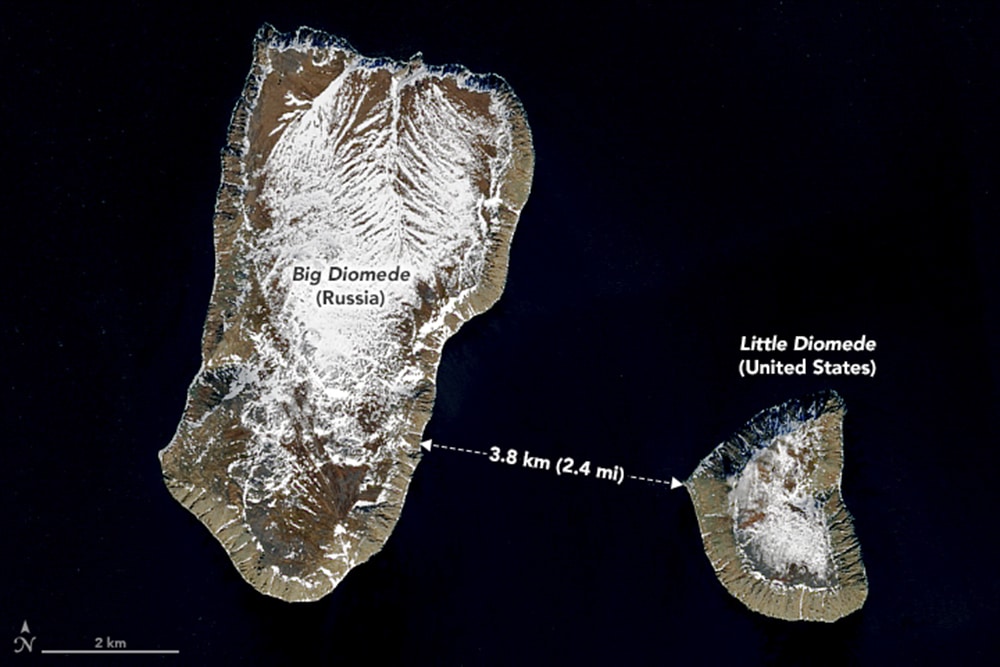
The border coincides with the International Date Line, so when Americans look across to the neighbouring island, they’re not only looking into another country, they’re looking into tomorrow. Despite the short distance, when it’s 9am on Saturday on Little Diomede, it’s 6am on Sunday on Big Diomede.
5. Ethiopia / Somaliland
A threadbare piece of rope marks the border between Ethiopia and Somaliland, an autonomous region of Somalia. The ramshackle barrier in the village of Wado Makhil has a rather laidback approach to customs.
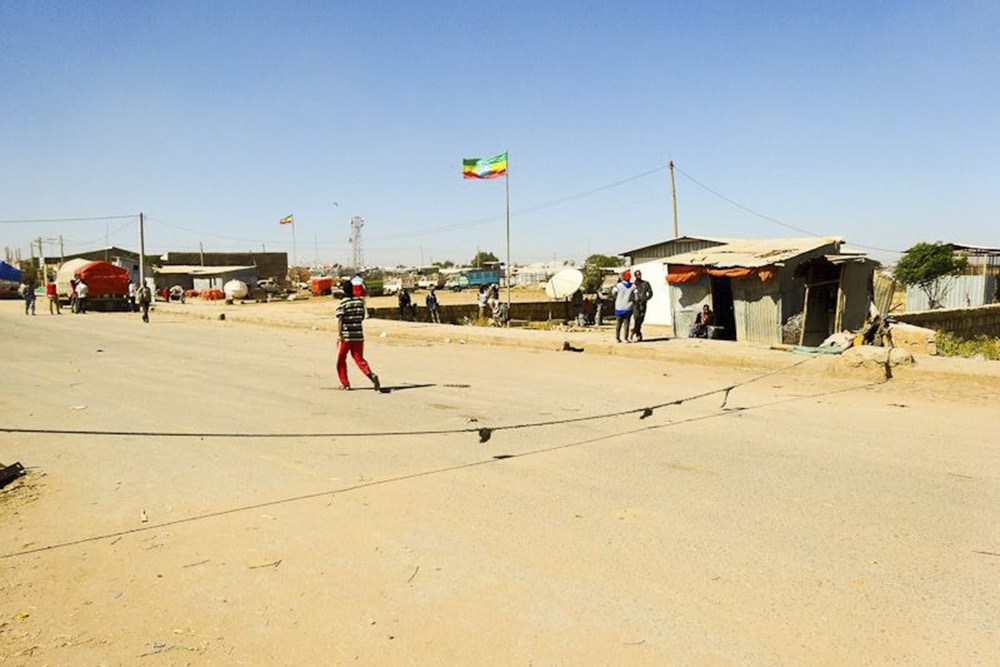
It reminds me of a 2010 trip during which I crossed the Tanzania–Kenya international border. On my way back from climbing Kilimanjaro, I arrived at a dusty outpost by coach and simply strolled into no man’s land between the two countries. I did buy a visa before entering Kenya and was amused to see that they had simply stamped it ‘Peter’ with no other details whatsoever.
6. North Korea / South Korea
This satellite image clearly shows the international borders between South Korea and its isolated neighbour. North Korea lies in darkness, its capital Pyongyang one of the few places with electricity.
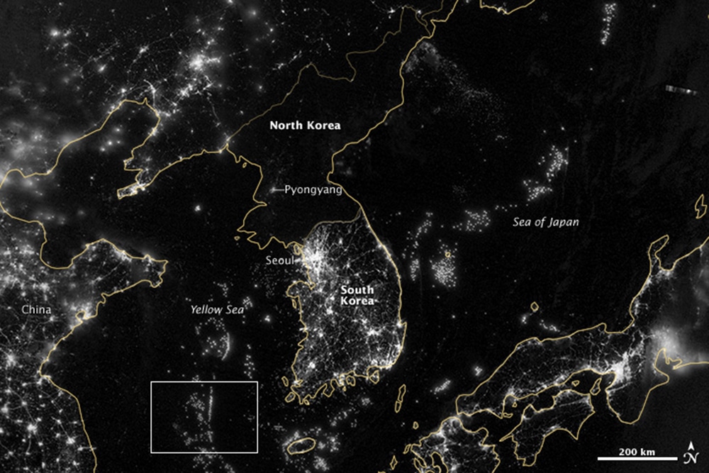
The lights at the top of the image depict cities in China while the line in the middle marks the DMZ (demilitarised zone). It’s said that night-time illumination is an indicator of economic prosperity.
By that measure, North Koreans are living in practical poverty. After the Arab Spring, South Koreans reportedly sent balloons across the border informing their long-suffering neighbours of the protests. Some hope for a similar revolution but in one of the most militarised countries in the world, it is near impossible.
7. Sweden / Norway
One of the few pairs in this list that actually like each other, Sweden and Norway share this stunning international border. With snow-capped trees on either side, the route stretches for over 1,000 miles, making it the longest border in either country.
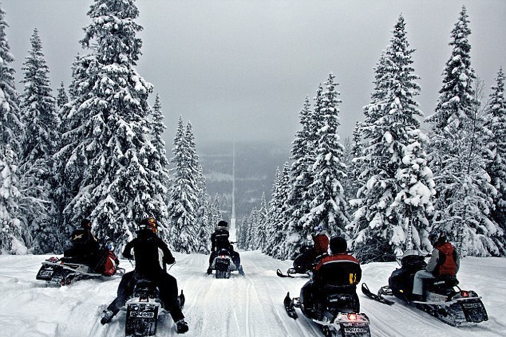
Photographer Havard Dalgrav posted a similar image to Reddit in 2012 garnering over 1,000 comments. He says in the thread: “Funny part is that riding a snowmobile for fun is illegal in Norway, but legal in Sweden. So we are riding on a very thin line here, literally…”
8. Papua New Guinea / Indonesia
From afar, the Papua New Guinea–Indonesia seems striking in its simplicity: a straight line that runs directly from north to south. Look closer and you’ll notice what looks like a small bite mark taken out of Indonesia.
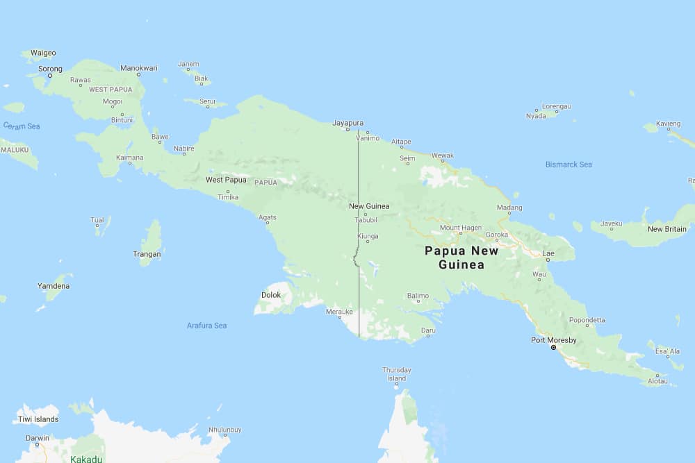
That bite mark is a bend in the Fly River, which strays to the west before levelling out into a straight line once again. It’s said that the anomaly is a result of headhunting (and not of the LinkedIn variety).
In 1893, the area was awash with actual, real headhunting. The British, who controlled the southeastern quarter, found it difficult to act due to the then ambiguous border.
The problem was solved by a deal that moved the border to the east, allowing British powers to patrol much further without having to cross international borders. The amendment is all the more remarkable as it has become the continental border between Asia and Oceania.
9. Mexico / USA
The Mexico-USA border has 350 million documented crossings annually, making it the world’s most frequently crossed international border. It extends from the Pacific Ocean in the west to the Gulf of Mexico in the east and is the source of much political strife due to the volume of undocumented border crossings.
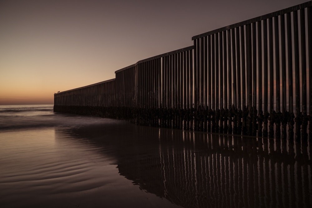
At its western terminus, the barrier extends 90 metres into the Pacific Ocean between Imperial Beach in California and Tijuana Beach in Mexico to prevent would-be migrants from walking over to the US during low tide. Occasionally, it serves as a fence in a friendly game of international beach volleyball.
10. Bangladesh / India
If you saw that image of a shipping ship shipping shipping ships a few years ago, then perhaps you’ll be able to process this more easily. Until 2015, Dahala Khagrabari was an Indian enclave inside a Bangladeshi enclave inside an Indian enclave inside Bangladesh.

At 7,000 square metres, it was the world’s only third-order enclave (or counter-counter enclave), which means if you drove straight through it you’d go through Bangladesh, India, Bangladesh, India, Bangladesh, India, Bangladesh.
Legend has it that the enclaves were a result of a series of chess games between the Maharaja of Cooch Behar and the Faujdar of Rangpur who waged villages instead of currency. Academics say it’s the result of peace treaties in 1711 and 1713 between the kingdom of Cooch Behar and the Mughal empire.
Because of its lack of public services, the enclave was ceded to Bangladesh in 2015 after much political wrangling.
Enjoyed this post? pin it for later…


